
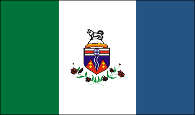
Yukon
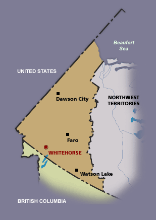 Capital: Whitehorse
Pray:
- Pray for the Aglow groups and leaders to be strengthened.
- Pray for all the resources and creativity needed to fulfill the intentions of God in the province of Yukon.
- Pray for the Aglow prayer group in the Capital city.
- Pray for godly government leaders. Blessed is the nation whose God is The Lord, the people whom He has chosen for His own inheritance. Psalm 33:12
Proclaim:
- Arise, shine; for your light has come! And the glory of the LORD is risen upon you. For behold, the darkness shall cover the earth, and deep darkness the people; but the LORD will arise over you, and His glory will be seen upon you. Isaiah 60:1,2 (NKJV)
- Lift up your heads, O you gates! Lift up, you everlasting doors! And the King of glory shall come in. Who is this King of glory? The Lord of hosts, He is he King of glory. Psalm 24:9-10 (NKJV)
Interesting Facts About Yukon
 Population: 36,700
Government: The Yukon Legislative Assembly consists of 17 elected members and functions in much the same way as a provincial legislature.
As a territory, the Yukon does not have full provincial status, although it achieved a style of government similar to that of the provinces in 1979. The Canadian government retains administrative control over water, land and forestry and the development of all non-renewable resources (i.e. minerals, oil and gas).
The 1970s saw the emergence of the Yukon Indian land claims negotiations. In 1993, the Council for Yukon Indians, the Government of Canada and the Yukon Territorial Government signed an Umbrella Final Agreement that sets out the terms for final land claim settlements in the Territory. Final land claim agreements were also reached with the Vuntut Gwich’in First Nation, the Champagne and Aishihik First Nation, the Teslin Tlingit Council and the First Nation of Nacho Nyak Dun.
These agreements contribute to certainty of land title, and benefits include cash, land and participation on wildlife and other management boards. In addition to their land claim settlements, the four First Nations also negotiated self-government agreements that give them more control over land use on settlement lands and greater authority in areas such as language, health care, social services and education.
People: The Yukon’s vast interior forests were occupied by the Athapaskans, whose cultural and linguistic traditions go back more than 1000 years. Today, there are six distinct groups of Athapaskan Indians: Kutchin, Han, Tutchone, Inland Tlingit, Kaska and Tagish.
At present, approximately 31 040 people live in the Yukon; 23 percent of the population is Aboriginal.
Almost 60 percent of the population lives in Whitehorse, Yukon’s capital city. Yukon Indians now comprise approximately 25% of the population of the territory. In 1987, 4716 resided in 13 bands. Although there are six small Indian reserves in Yukon, only a few are occupied and the Indian Act reserve system has never been highly developed. Yukon Indians live side by side with non-native residents in every community in the Yukon and form the majority of the population in more remote villages. Since 1973, Yukon Indians have been negotiating a comprehensive land-claim settlement.
History: The Yukon was the first area in Canada to be settled by people. It is believed ancestors of the Amerindians inhabited the Yukon 10 000 to 25 000 years ago when they migrated from Asia across a Bering Sea land bridge. The first modern European visitors were Russian traders in the 18th century. Sir John Franklin anchored off the Yukon’s Arctic coastline in 1825, and the Hudson’s Bay Company moved into the interior in the 1840s using maps and information from Franklin and other early explorers. The Hudson’s Bay Company first used the name Yukon in 1846. They named it “Yucon,” from the Loucheux Indian word “Yuchoo,” meaning the greatest river. U.S. traders arrived after the 1867 Russian sale of Alaska to the United States.
Historically, the Yukon is associated with the great Klondike Gold Rush. On August 17, 1896 George Carmack discovered gold on Bonanza Creek, a tributary of the Klondike River. This discovery marked the beginning of what is often considered the world’s greatest gold rush. After centuries of quiet habitation indigenous peoples found their lands inundated as gold prospectors pushed northwards from northern British Columbia or moved inland from the Bering Sea. Miners also traveled up the Yukon River by sternwheeler. The town, then city, of Dawson, at the junction of the Klondike and Yukon rivers, and named after the chief Canadian surveyor, came into existence to serve the great gold rush influx.
In 1898, the Canadian government officially established the Yukon Territory. The North West Mounted Police were sent in to ensure Canadian jurisdiction and The Yukon Act provided for a commissioner and an elected legislative assembly. That year, in one month, Dawson grew into the largest Canadian city west of Winnipeg, developing a complete range of services including water, sewerage, electricity and telephones. At its peak, the population has been estimated at 40,000. Between 1897 and 1904 over $100 million in gold was recovered from the creek gravels of the Yukon. By 1906 the most easily worked placer mines were finished, leaving claims to be mined by large companies using expensive dredges.
With the decline in gold the population decreased significantly and the economy returned to its old routes. Yukon’s economy shifted from gold to other minerals beginning in 1913 when its first hardrock mine started silver and lead production at Keno Hill in the central Yukon. A mill was later established at nearby Elsa with services in the community of Mayo. High fur prices made trapping an important seasonal activity in the 1930s for native people and prospectors, in the absence of any other industry.
During World War II the United States Army built the Alaska Highway from Alaska to Alberta, creating a new overland transportation route through the Yukon. The WWII construction and the building of the Canol pipeline and road led to new mineral exploration activity and brought people, services, industries and tourists to the Yukon after the war. With the highway came a permanent non-native population that outnumbered Yukon’s indigenous peoples for the first time. Yukon’s capital was transferred from Dawson to Whitehorse in 1953 .In 1979 the Canadian government opened the Dempster Highway, Canada’s first all-weather road to cross the Arctic Circle.
Interesting Facts information from the library.educationworld.net/canadafacts website. Read more about Yukon